


crêtes du mont Rachais

CABERMAT
User
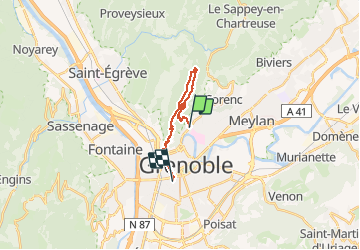

Length
15.8 km

Max alt
1043 m

Uphill gradient
937 m
Km-Effort
28 km

Min alt
208 m

Downhill gradient
963 m
Boucle
No
Creation date :
2021-05-03 09:17:57.48
Updated on :
2021-05-03 17:16:48.915
4h21
Difficulty : Medium

FREE GPS app for hiking
 SityTrail
IGN / Geographical institutes
SityTrail Plus
The world is yours!
About
Trail Walking of 15.8 km to be discovered at Auvergne-Rhône-Alpes, Isère, La Tronche. This trail is proposed by CABERMAT.
Positioning
Country:
France
Region :
Auvergne-Rhône-Alpes
Department/Province :
Isère
Municipality :
La Tronche
Location:
Unknown
Start:(Dec)
Start:(UTM)
715056 ; 5009414 (31T) N.
Comments